 Location: (Ethiopia)
 Vacancies: 1
 Work modality: On site
Introduction:
Ayuda en Acción is a secular, non-partisan, and non-governmental organization founded in 1981, with a global commitment to combating poverty, inequality, and exclusion. Its headquarters are located in Madrid, Spain, and it operates in 18 countries across Africa, South and Central America, and Europe (Spain and Portugal).
In Ethiopia, Ayuda en Acción worked through local partners to deliver a range of humanitarian and development programs between 2002 and 2017. In 2018, the organization established an independent country program. Ayuda en Acción Ethiopia is committed to tackling the underlying causes of poverty, inequality, and exclusion, placing women, men, girls, and boys at the centre of its interventions. Its approach focuses on strengthening the capacities of both individuals and institutions to actively contribute to development and to promote a dignified life for all Ethiopians.
To fulfill its mission, Ayuda en Acción Ethiopia has worked in three regions: Afar, Oromia (Arsi and Borena), and the Southern Nations, Nationalities, and Peoples’ Region (SNNPR) in close collaboration with local partners, international research institutions, public agencies, and private sector stakeholders. Thematically, AeA has been implementing long-term interventions on market system development, employment, access to quality education, sustainable food and adaptation to climate change, and mainstreaming gender equality and environmental protection.
Ayuda en Acción has been operational in Borena since 2017, working closely with local partners to deliver humanitarian response, recovery, and resilience-building interventions. Since 2020, the organization has been implementing an integrated program in Borena Zone, targeting pastoral communities significantly affected by poverty, recurrent climate shocks, and conflict.
Currently, AeA is implementing programmes focused on advancing market system development, promoting sustainable rangeland management, water development, fostering digital innovations for resilience, enhancing pastoral financial inclusion, scaling up Index-Based Livestock Insurance, and empowering women and youth. These interventions are anchored in a nexus programming approach, designed to strengthen local capacities while generating evidence to inform policy dialogue and advocacy.
Background of the study areas:
Borena Zone is located in the southeastern part of Ethiopia, within the arid and semi-arid lowland areas of the country. The zone has an estimated total population of over one million people, of which approximately 94 percent are rural pastoralists. Administratively, Borena Zone is divided into 13 districts. It shares boundaries with West Guji Zone to the north, the Southern Nations, Nationalities, and Peoples Region (SNNPR) to the west, the Somali Region to the southeast, and Kenya to the south.
Borena Zone experiences a bimodal rainfall pattern with two distinct rainy seasons. The main rainy season, known locally as Ganna, occurs from mid-March to mid-May, while the short rainy season, Hagaya, extends from September to November. These rainfall patterns are critical for sustaining the pastoral and agropastoral livelihoods predominant in the area.
Pastoralism serves as the primary livelihood and cultural identity of the Borena community. Both pastoralism and agropastoralism provide the main sources of food security and income. However, these systems face increasing challenges due to recurrent droughts driven by climate change. The Borana pastoral production system is characterized by mobility, people and livestock move seasonally across geographically distributed grazing and watering sites. This mobility is a deeply rooted traditional strategy that allows for efficient utilization of the dispersed and patchy rangeland and water resources typical of dryland ecosystems.
Rangeland resources in Borena are managed collectively under customary common property arrangements. The Borana pastoral community has, for centuries, governed these resources through indigenous systems that emphasize sustainability and ecological balance. Their management approach follows an ecosystem-based model, relying on seasonal variations in pasture and water availability.
The Borana pastoralists possess a well-established indigenous governance system that regulates access to and management of rangeland resources. The rangeland is divided into five major grazing units, known locally as dheeda, each defined by distinct physical characteristics. Leadership within this system follows a hierarchical structure. The overall leader of the Borana community is the Aba Gada, while each dheeda is overseen by an elder referred to as the Aba Dheeda (literally “father of the dheeda”). Each dheeda is further subdivided into smaller grazing units called reera.
This traditional governance and ecological knowledge system has enabled the Borana community to sustainably manage their environment for generations, ensuring equitable access to natural resources and resilience against environmental shocks.
Livestock is a source of food for the population; it is a means of generating income for sustaining livelihoods. Unfortunately, pastoralism as a means of livelihood is challenged by climate change-induced drought which contributes to natural resource degradation and has significantly depleted household assets (chiefly, livestock) and eroded traditional pastoral livelihoods, leading to food insecurity, poverty and resource use conflict. For instance, the drought in 2018/19 has led to a 60% loss in the livestock population in the region.
A previous assessment, the Participatory Rangeland Condition Assessment conducted in Gomole and Dirre Dheedas of Ethiopia, confirmed the deteriorating state of rangeland resources in the area. According to the Borana Zone Disaster Risk Management (DRM) Office, during the 2016/2017 drought, an estimated 30 percent of the livestock population perished. Shortages of pasture weakened livestock body conditions, further aggravating drought-related livestock diseases.
Furthermore, findings from Trócaire’s 2014 baseline survey of the Livelihood Program corroborate these observations. The study highlighted that the frequency of drought shocks has intensified, shifting from 5–10-year intervals to just 3–5-year cycles. Consequently, household assets—primarily livestock—have not had sufficient time to recover. This depletion of productive assets has heightened vulnerability and exacerbated resource-related conflicts over rangelands and water sources. Overall, the combined evidence from these assessments underscores the urgent need for sustainable rangeland management and drought resilience interventions in the Borana Zone.
Project description:
The HORA BULA (Helping Ongoing Resilient Action: Building and Upscaling Lessons Learned for Anticipatory Action) financed by the Italian Agency for Development Cooperation (AICS), The project aims to contribute to mitigating the effects of multiple shocks in communities affected by both natural disasters and human-induced risks across Oromia Region. Its overall goal is to strengthen the resilience of vulnerable populations by capitalizing on lessons learned from ongoing humanitarian experiences and integrating them into long-term resilience-building efforts.
The project focuses particularly on food security interventions through cash transfers (both conditional and unconditional), distribution of agricultural inputs, and support to veterinary services. Additionally, it seeks to enhance disaster risk reduction planning from an anticipatory perspective, linking national frameworks with local structures and establishing digital platforms for effective information flow.
The project’s specific objective is to improve the capacity of communities to promote, protect, and restore their food security in a sustainable manner. This involves empowering local households and institutions to prepare for and respond to recurrent shocks—such as droughts, livestock diseases, and market disruptions—through early action and better access to essential services. By strengthening the adaptive capacity of households, HORA BULA promotes community ownership and resilience, ensuring that short-term assistance is complemented by long-term preparedness and self-reliance.
The logic of intervention builds on two complementary dimensions. First, it strengthens the conditions for food security by improving access to veterinary services, enhancing the availability of agricultural inputs, and providing immediate livelihood support to the most vulnerable groups. Second, it enhances community and institutional mechanisms for disaster risk reduction through anticipatory approaches focusing on improved decision-making, data management, and early warning systems. Together, these strategies ensure that communities can act before crises escalate, reducing the negative impacts of recurrent shocks.
Ultimately, the project enables families in the Borena Zone specifically in Dubuluk, Dirre, and Moyale districts to respond more resiliently to multiple and overlapping shocks. By fostering participatory solutions, the project strengthens local decision-making processes and community autonomy while maintaining strong linkages with regional and national disaster management systems.
Implemented jointly by Ayuda en Acción and CESVI, HORA BULA promotes a model of integrated humanitarian and development action that builds lasting resilience and contributes to sustainable livelihoods in pastoral and agro-pastoral communities.
Traditionally the pastoral community migrates with their livestock during dry seasons in search of pasture and water using traditional information exchange and indigenous knowledge. Borana pastoralists have a well-established grazing management tradition which is based on seasonal mobility for the utilization of grazing lands. This seasonal mobility usually follows the ‘abuurraa’ which means assessment of available grass and water. During the assessment, an individual or a group of scouts’ travel across a given rangeland which can be in Borana territory or out of it, and search for available and accessible grazing land. After their return a larger group may move with their livestock. This traditional system of information exchange has been there for generations. Despite the existence of local knowledge, the indigenous information system can benefit from increasing its efficiency.
Modernising the information sharing using digital technology complements the local information exchange with geolocation satellite-based digital information. It has paramount importance to minimize the herd loss and conflict during the movements. Nowadays, solutions based on Information and Communication Technologies (ICTs) can overcome these limitations. ICTs such as Geographic Information System (GIS) can be used to transmit and to keep up-to-date information between people that live in pastoral areas. Similar experience like Afriscout has been piloted in Kenya by Project Concern International. The International Livestock Research Institute oversees sharing satellite data; Normalized Difference Vegetation Index (NDVI) to monitor drought indicators (greenness of the area/availability of pasture), announce insurance playouts for IBLI policy holders, design insurance contracts, and develop insurance units based on rigorous time series data and community consultation.
AeAE has developed a mobile application where pastoralists could access reliable and timely information on the availability of pasture, water, and other information (insurance pay-outs based on ILRI seasonal announcement, animal disease, market information) through their mobile phone and established Pastoralist Information centres. This will support the pastoralists in Dubuluk, Dirre and Moyale districts to make informed decision of routes and destinations of seasonal livestock movements.
Given the project objectives, AeAE and its partners now intend to recruit an experienced consultancy firm to conduct participatory mapping and geolocation of all water structures, greenness/availability of pasture and other information integrates indigenous knowledge with formal maps. This enhances access to GIS/satellite data on availability of pasture, water and other information needed by pastoralists to make decision on the route and places to move to with their livestock.
Digitally capturing local knowledge and feeding back the results will be used for an in-depth exploration of the potential of satellite images, Geographical Information System (GIS) and local knowledge. To that end, using the geospatial information pastoralists can easily access digital information both through customized online (mobile app) and offline (pastoralist information centres established by the project in six kebeles).
Objectives of the study :
The general objective of the study is to develop participatory geospatial mapping, which helps to access up-to-date digital information on the availability of pasture, water, and other information to optimize seasonal livestock migration of pastoralists in Dubuluk, Dirre and Moyale districts of Borena zone.
Specific objectives:
Scope of the work:
The scope of the assignment includes:
Methodology:
The selected consultancy firm will propose an appropriate methodology while integrating the methods and tools proposed below. Additional, appropriate methods and tools may be proposed by the selected consultant.
The consultant will undertake collection of all the required data/information from various sources, including community, individuals, community-based organisations, Government Sector offices (district to federal levels) and other relevant sources.
During the data collections and analysis, the consultancy firm will, at the minimum, follow these steps listed below:
Step 1: Desk review and higher-level stakeholder consultation: in-depth review of available rangeland mapping, rainfall (metrological data), climate shocks, conflict, diseases, historical NDVI/satellite data, current insurance unit, consult ILRI, etc. This will help the consultant (s) to determine the focus, use available resources, better understand the study areas, and help to design the tools. The steps are not mutually exclusive.
Step 2: District/zonal and community level data collections: (the following points are not exhaustive): Qualitative and quantitative data will be collected.
Step 3: Bringing together community resource maps: (from Step 1) with the satellite imagery/Google. Participants locate key resources or their indicators from and place an icon to show their precise location. This produces the coordinates that pinpoint the locations of natural resources in a manner that can be independently and objectively verified.
Step 4: Spatial and attribute data can be added by several groups and pooled on one map: allowing more cross checking, detail, and area coverage. Qualitative and quantitative data describing the attributes of these key resources will also be collected (Step 1 including collecting GPS marks for key features).
Step 5: Spatial data from Google Earth is merged with the attribute data recorded in Excel: The two data sources will be later merged into file formats for use in a GIS, with the attributes of natural resources embedded into the spatial data describing their locations.
GIS maps of the study area will be produced with the attributes embedded and participants' choices of base map, icons and colour schemes. This transformation allows all the data collected to be shown on a single, easy to interpret platform that allows processing, printing, sharing and analysis. Map will be produced to scale. Use free, open-source platform that is far easier to share and handover.
Step 6: Field validation: Feedback of the map to groups who provided data, local government, and other interest groups. Data is returned for participants to evaluate and validate the maps and to reach consensus between the various groups. This allows the maps to be returned for validation, cross-checking, and styling according to the needs of those who provided the data, building trust as well as more refined, readable, and validated maps.
Throughout the process, community discussions are facilitated, there is a review of management systems, and all map features are agreed upon. Cross-community discussions and agreements on system boundaries and cross-system reciprocal use rights are also facilitated.
Step 7: GPS marks for contentious features, those undiscernible from, or newer than, the satellite imagery and those which demonstrate the accuracy of the map must be collected on the ground.
Data source and collection tools:
Activities / Tasks of the consultancy firm:
The selected consultancy firm will undertake the following key tasks include:
Responsibilities of Ayuda en Acción Ethiopia:
AeAE will provide:
Deliverables:
The successful candidate for this consultancy assignment will deliver the following:
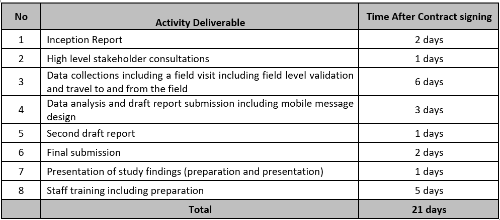
Duration:
The project will need to be completed within the below explicitly mentioned time frame. The consultancy period is 21 calendar days.
Minimum requirement of the consultancy firm and team members:
Minimum requirements of the consultancy firm include:
Technical and financial offer:
Submitted bid documents must fully comply with this TOR and must contain both technical and financial sections.
The technical proposal shall include:
The financial offer shall include:
The Consultant must adhere to all AeAE policies concerning Code of Conduct and Safety and Security.
Criteria for Selecting the Best offer:
The selection of the proposal will be done by using the Combined Scoring method, where the qualifications and methodology will be weighted a maximum of 70% and combined with the price offer which will be weighted a maximum of 30%. The technical part of the application will be assessed based on previous experiences of the applicants. The following technical elements will be considered:
The selection committee will evaluate the proposals based on a best-value determination.
Line of reporting:
The Consultant Firm must report to the contact person in Ayuda en Accion Ethiopia – Programme Director as per the schedule of the assignment. The Programme Director will lead the selection committee and will submit the report to AeAE’s Country Director based on the selection.
Terms of Payment:
Payments will be made according to the following schedule.
Application Instructions:
Interested and eligible consulting firms are invited to submit their Letter of Interest, along with scanned, stamped copies of the Technical and Financial Proposals, exclusively through Ayuda Talent Clue system, within ten (10) consecutive days from the date of this advertisement.
Submission Requirements:
You may send your questions prior to submission to: Ermiyas Tadesse, Programme Director etadesse@ayudaenaccion.org or Bitsit Endale, Operations Director bendale@ayudaenaccion.org or for inquiries related to application procedures, please contact Andenet Tadesse, HR and Admin at atadesse@ayudaenaccion.org
In all selection processes, we will consider the criteria of NO discrimination based on sex, race, skin colour, religion, political ideas, social origin, sexual orientation, age, etc., providing a transparent and equal opportunity process for all candidates, as stated in our Code of Conduct. "Treating all people with respect and rejecting any kind of harassment, discrimination, intimidation, exploitation or any other action against Human Rights".
At Ayuda en Acción we have zero tolerance for behavior related to sexual exploitation, sexual abuse, and/or sexual harassment, which is why, in accordance with our Child Protection Policy, we are committed to carrying out a series of checks prior to hiring by requesting information from previous employers through the Misconduct Disclosure Scheme (The Misconduct Disclosure Scheme misconduct-disclosure-scheme.org) no the event that said employers are members of this platform.
In addition, Ayuda en Acción also undertakes to provide the other members of the MDS with the information corresponding to this type of event on employees who have worked for the Organization. Therefore, by submitting this application, the applicant accepts and authorizes the performance of these pre-employment checks in order to continue in the selection process and the conservation of his/her data for subsequent consultation by MDS members. The information extracted from this application for references will be used in a Private, Confidential and Internal manner and will only be used for the selection processes of Ayuda en Acción in which the candidate has registered. Therefore, by submitting this application, the applicant accepts and authorizes these checks to be carried out in order to continue in the selection process. In addition, it will be compulsory to present the "Negative Certification of the Central Registry of Sex Offenders" prior to the incorporation.